

Dzisiaj na grupie pl.rec.gps GPSManiak poruszył ciekawą kwestię "odporności" modelu 60csx na poprawny odbiór korekty z satelitów przekazujących sygnał w systemie EGNOS (33, 37, 39). Ponieważ mnie również ta kwestia nurtuje chciałbym prosić doświadczonych użytkowników Garmina o komentarz do poniższych uwag, które zebrałem w sieci.
Problem ten nie wynika z usterek firmware'u a dotyczy urządzeń "amerykańskich' użytkowanych w Europie. Wynika on z faktu, że odbiorniki te mają almanach danych (korekta jonosferyczna, efemerydy, korekta czasu itd.) przygotowany dla Ameryki. Rozwiązaniem może być "master reset" oraz późniejsze umożliwienie odbiornikowi w stabilnej pozycji przez pewien czas (od kilku minut do... kilku kodzin!) pobranie nowych, poprawnych dla Europy danych - oczywiście z włączoną funkcją WAAS/EGNOS. Tutaj jest link: http://gpsinformation.biz/phpBB2/viewtopic.php?p=11662&sid=75f680d5b0c6caae58ca092a5b2a17f5
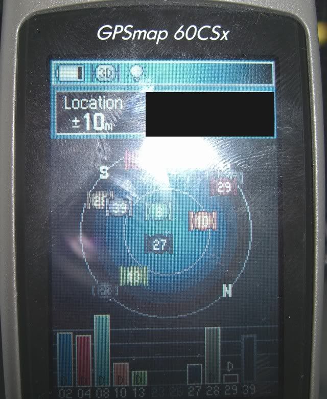
Z drugiej strony gdzieś znalazłem wypowiedź użytkownika 60csx, w której potwierdził problem z sygnałem EGNOS, ale jednocześnie napisał, że skutecznie go usunął w bardzo prosty sposób: poprzez pozostawienie odbiornika z włączoną funkcją EGNOS na ok. 45 min (aż do pojawienia się oznaczeń "D" na słupkach satelitów). W tym przypadku urządzenie skutecznie nauczyło się jak korzystać z EGNOSA bez "master resetu" i od tego momentu bardzo szybko, bez problemu fiksuje się na poprawki.
Pozdrowienia!
60csx vs EGNOS
Moderatorzy: Spider, Magnoom, GPS Maniak
Posty: 57 • Strona 1 z 4 • 1, 2, 3, 4
60csx vs EGNOS
![]() przez Grzegorz » Pn, 23 kwi 2007 20:07
przez Grzegorz » Pn, 23 kwi 2007 20:07
- Grzegorz
- Początkujący
- Posty: 11
- Dołączył(a): Cz, 22 mar 2007 22:06
Re: 60csx vs EGNOS
![]() przez GPS Maniak » Pn, 23 kwi 2007 21:01
przez GPS Maniak » Pn, 23 kwi 2007 21:01
Grzegorz napisał(a):skutecznie go usunął w bardzo prosty sposób: poprzez pozostawienie odbiornika z włączoną funkcją EGNOS na ok. 45 min (aż do pojawienia się oznaczeń "D" na słupkach satelitów).
U mnie to nie zadziałało. Ogniwa padły, a "D" jak niebyło, tak nie było. O wcześniejszym resecie też pomyślałem. I nic. Nie wiem tylko jako jest różnica pomiędzy resetem "Hard" a "Master"
Pozdrawiam Lechu
Plecak: Garmin Fenix 5X + Xiaomi Mi Max 2 a czasami: Oregon 600T, Rino530HCX Był: Summit, Vista, 60CS, 60CSX, 62ST, eTrex30, eTrex10, Fenix3, Epix
Samochód: 3490T Był: 200, 205T, 1200T
Plecak: Garmin Fenix 5X + Xiaomi Mi Max 2 a czasami: Oregon 600T, Rino530HCX Był: Summit, Vista, 60CS, 60CSX, 62ST, eTrex30, eTrex10, Fenix3, Epix
Samochód: 3490T Był: 200, 205T, 1200T
-

GPS Maniak - Radny
- Posty: 14830
- Dołączył(a): Pt, 16 mar 2007 2:55
- Lokalizacja: Poznań / Lesko
![]() przez soko » Pn, 23 kwi 2007 21:16
przez soko » Pn, 23 kwi 2007 21:16
Grzegorz:
Myślałem dotąd, że odbiornik każdorazowo pobiera te dane z sygnału z satelitów.
No i na logikę, tak powinno być.
Krzysztof.
Wynika on z faktu, że odbiorniki te mają almanach danych (korekta jonosferyczna, efemerydy, korekta czasu itd.) przygotowany dla Ameryki.
Myślałem dotąd, że odbiornik każdorazowo pobiera te dane z sygnału z satelitów.
Z drugiej strony gdzieś znalazłem wypowiedź użytkownika 60csx, w której potwierdził problem z sygnałem EGNOS, ale jednocześnie napisał, że skutecznie go usunął w bardzo prosty sposób: poprzez pozostawienie odbiornika z włączoną funkcją EGNOS na ok. 45 min (aż do pojawienia się oznaczeń "D" na słupkach satelitów). W tym przypadku urządzenie skutecznie nauczyło się jak korzystać z EGNOSA bez "master resetu" i od tego momentu bardzo szybko, bez problemu fiksuje się na poprawki.
No i na logikę, tak powinno być.
Krzysztof.
60CSx, Colorado 400t, Suunto X10, Colorado 300 i Colorado 400c. 86S, 79S.
Moja "Instrukcja Obsługi Colorado": Link: viewtopic.php?p=67948#p67948
Moja "Instrukcja Obsługi Colorado": Link: viewtopic.php?p=67948#p67948
-

soko - Garniak
- Posty: 1767
- Dołączył(a): Pt, 16 mar 2007 16:59
- Lokalizacja: Poznań
![]() przez Grzegorz » Pn, 23 kwi 2007 21:43
przez Grzegorz » Pn, 23 kwi 2007 21:43
Myślałem dotąd, że odbiornik każdorazowo pobiera te dane z sygnału z satelitów.
No, właśnie: też tak myślałem. Ale zastanawiam się, czy dla satelitów EGNOS nie stosuje się jakiegoś innego typu reguł transmisji danych, związanych z ich specyfiką (lokalizacja na orbicie geostacjonarnej)?
- Grzegorz
- Początkujący
- Posty: 11
- Dołączył(a): Cz, 22 mar 2007 22:06
![]() przez GPS Maniak » Pn, 23 kwi 2007 22:10
przez GPS Maniak » Pn, 23 kwi 2007 22:10
soko napisał(a):Myślałem dotąd, że odbiornik każdorazowo pobiera te dane z sygnału z satelitów.
Z satelitów GPS tak. Z WAAS niekoniecznie. W końcu są geostacjonarne.
Zobaczcie to: Changes made from version 2.50 to 2.60: Updated WAAS almanacs.
To pochodzi stąd:
https://buy.garmin.com/shop/store/downl ... 45&pID=310
I tu może być faktycznie pies pogrzebany.
No nic. Porobiłem resety i wyrzuciłem odbiornik na balkon. Tyle, że wydaje mi się, że ostatnio wybudowana chata nieco mi zasłania sygnał "33". Jeżeli nic nie wskóram wrócę do zabawy dopiero w czerwcu na Połoninach
Pozdrawiam Lechu
Plecak: Garmin Fenix 5X + Xiaomi Mi Max 2 a czasami: Oregon 600T, Rino530HCX Był: Summit, Vista, 60CS, 60CSX, 62ST, eTrex30, eTrex10, Fenix3, Epix
Samochód: 3490T Był: 200, 205T, 1200T
Plecak: Garmin Fenix 5X + Xiaomi Mi Max 2 a czasami: Oregon 600T, Rino530HCX Był: Summit, Vista, 60CS, 60CSX, 62ST, eTrex30, eTrex10, Fenix3, Epix
Samochód: 3490T Był: 200, 205T, 1200T
-
GPS Maniak - Radny
- Posty: 14830
- Dołączył(a): Pt, 16 mar 2007 2:55
- Lokalizacja: Poznań / Lesko
![]() przez GPS Maniak » Wt, 24 kwi 2007 8:35
przez GPS Maniak » Wt, 24 kwi 2007 8:35
No i kicha ..... Odbiornik przeleżał na tarasie od 23.oo do 9.oo i nie załapał EGNOSA 
Ale wszystko ma swoje dobre strony Przy okazji zauważyłem że moje nowe aku 2700 mają szanse wytrzymywać 20 godz. Po 10 godz. ciągłej pracy nadal mam 3 kreski.
Ale wszystko ma swoje dobre strony
Pozdrawiam Lechu
Plecak: Garmin Fenix 5X + Xiaomi Mi Max 2 a czasami: Oregon 600T, Rino530HCX Był: Summit, Vista, 60CS, 60CSX, 62ST, eTrex30, eTrex10, Fenix3, Epix
Samochód: 3490T Był: 200, 205T, 1200T
Plecak: Garmin Fenix 5X + Xiaomi Mi Max 2 a czasami: Oregon 600T, Rino530HCX Był: Summit, Vista, 60CS, 60CSX, 62ST, eTrex30, eTrex10, Fenix3, Epix
Samochód: 3490T Był: 200, 205T, 1200T
-
GPS Maniak - Radny
- Posty: 14830
- Dołączył(a): Pt, 16 mar 2007 2:55
- Lokalizacja: Poznań / Lesko
![]() przez Grzegorz » Wt, 24 kwi 2007 21:45
przez Grzegorz » Wt, 24 kwi 2007 21:45
Niestety amerykański support Garmina "plącze się w zeznaniach" odpowiadając na reklamacje kilentów związane z odbiorem korekty WAAS - w moim poprzednim poście pisałem, że problem może wynikać z faktu użytkowania amerykańskich modeli w Europie, ale jak się okazuje w samej Ameryce też jest znany. Mam wrażenie, że Garmin po prostu nie wie dlaczego jedne egzemplarze 60csx odbierają WAAS/EGNOS a inne nie. Są podejmowane jakieś rozpaczliwe próby odszukania źródła usterki to w opogramowaniu firmware, to w działaniu chipset SiRF Star III a nawet w wadliwej transmisji syganłu z satelitów WAAS/EGNOS. Garmin radzi aby nie przywiązywać zbyt dużej wagi do tego problemu i dać sobie spokój, chociaż odbiorniki serii "X" są wyraźnie rekalmowane jako współpracujące z WAAS/EGNOS a to dla niektórych może mieć decydujący wpływ na podjęcie decyzji kupna (np. do Geocaching-u).
Oto niektóre "dziwne" odpowiedzi z amerykanskiego supportu Garmina:
"Nowe urządzenia z SiRF-em nie współpracują poprawnie z WAAS, jednak ich precyzja jest tak duża, że korekta WAAS niewiele może zmienić. Z tego powodu funkcja WAAS/EGNOS może być w przyszłości zaniechana w odbiorikach - brak potencjalnych korzyści."
"Dokładność urządzenia jest praktycznie identyczna zarówno z WAAS jak i bez niego."
"(...) Inną ważną kwestią jest to, że odbiorniki SiRF nie wyświetlają "D" nawet gdy są poprawnie zafiksowane na WAAS."
"Odbiorniki "X" nie odbierają sygnału WAAS."
"Żaden z nowych odbiorników z chipsetem SiRF'a nigdy nie pokaże "wypełnionego" słupka satelitów WAAS/EGNOS sugerującego, że odbiornik otrzymuje efemerydy z tych satelitów. Jednocześnie literą "D" są oznaczone słupki sygnałów z satelitów GPS, co oznacza aktywne pozycjonowanie różnicowe."
Tutaj jest dowód, że 60csx jednak POTRAFI korzystać z WAAS/EGNOS:
Nie należy jednak tracić nadziei! Są osoby, którym po baaaaardzo długim czasie, nagle i niespodziewanie zaczął działać WAAS.
Może i do nas kiedyś uśmiechnie się EGNOS...
- Grzegorz
- Początkujący
- Posty: 11
- Dołączył(a): Cz, 22 mar 2007 22:06
![]() przez soko » Wt, 24 kwi 2007 22:17
przez soko » Wt, 24 kwi 2007 22:17
Tutaj jest instrukcja jak załadować WAAS / EGNOS do Garmina:
http://www.gpsinformation.org/dale/dgps.htm
Jest to rozdział "Loading the Almanac" . Opisano to krok po kroku
Ale może lepiej cały wkleić do forum ( bo to taka instrukcja obsługi):
Loading the Almanac
The latest released products from Garmin, Magellan, and others include WAAS capability (called EGNOS in europe and MSAS in Japan). For Garmin this includes the etrex: Venture, Legend, and Vista models as well as the GPSMap76, GPS76, and Garmin V. They have also updated some other units with this capability such as the aviation units like the GPS 295 and the Street Pilot 2610. Almost all new units Garmin have been release with WAAS support. However, unlike the standard GPS almanac that is preloaded into each Garmin receiver, the WAAS almanac is not loaded into the receiver when you get it. Each person is required to get the almanac for themselves and this is required before it can be used in WAAS mode. Some folks are able to get an almanac fairly quickly while others struggle for days and are still not able to get a successful load. Here is the technique that will result in obtaining the almanac in the minimum amount of time.
1. Study the map of WAAS GEO satellites and determine which ones you are going to be able to see from your location. From the west coast of the US you can access number 47 and number 35 while from the east coast you can only see number 35. (Also the EGNOS 33 of course.) Update: (3/15/2006) The US satellites are moving and being replaced simultaneously. You can now see WAAS satellites at 35, 38, 47, and 48 depending on where you live and what tests are being performed. Expect this to settle down in September of 2006.
2. Find a place with a clear sky view in the direction of the WAAS GEO satellites you are interested in. If necessary set a waypoint to their approximate location so that you can use the GPS itself to provide a bearing to the satellite. For the USA GEOS 35 is at Lat 0 and Lon 54 West while 47 is at Lat 0 and Lon 178 East. For the European EGNOS system satellite 33 is at Lat 0 Lon 15.5 West and 44 is at Lon 65.5 East. (A new third Satellite called ESA Artemus is at Lon 21.5 East and is expected to come online for Navigation use in the October 2003 and is not shown on the above map.)
3. Be sure that your GPS is set to normal mode (not battery save) for this procedure. The nature of WAAS corrections precludes its use in Garmin battery save mode.
4. Enable WAAS on your GPS and notice that it takes the last two locations on the satellite page to display WAAS Geo activity. It will cycle through all of the 19 possible satellite locations 2 at a time and then repeat until two candidate satellites are found. It stays at one setting for about 45 to 50 seconds and then selects a new pair of SV's to look for. When it doesn't have a loaded almanac it will show the SV's on top of the N indicator on the satellite page.
5. When it reaches the ones you know it should see you need to make sure that the SV shows some receive strength. It it doesn't then reposition the unit in an attempt to find either a location or a direction that will cause the signal bar to appear. You only have 45 seconds so you need to try several positions to get that signal bar. Point directly at the SV, change the angle slightly (up to 90 degrees) and tilt the antenna in the direction of the SV, leave it in each trial position for a few seconds and if not successful then try another setting. You may need to move a little. The tree you thought was out of the way may be blocking the signal.
Once the satellite strength bar appears you are home free. It will not move off of that SV any longer although the second position will continue to hunt for another SV unless it too gets a signal bar. You can reposition slightly to help the second one lock on as well but be careful that you don't lose the first one.
6. Hold the unit until the full Almanac gets loaded. This will be indicated by the satellite(s) assuming the correct position on the page and will usually turn solid (but this is not a requirement). The figure on the right shows two GEO SV's in position from a location in California. When the satellite is in position and collecting data it will also begin working by starting to display small D's on the other satellite bars to indicate that they are in differential mode. It can take up to 5 minutes to load the almanac data and if it misses any of the data you could wait another 5 minutes for it to come around again. If it grabs an SV that does not have land data for your area it could take quite a while for it to figure this out, but it will eventually supply some amount of differential correction.
7. If the unit seems to ignore a satellite you know it should see and then switches and moves on to other satellites without generating a signal bar then you may need to re-evaluate your location and find a better spot with a few in the direction of the satellite. You will need to wait until it gets back to your satellite location before trying again. If you are searching for a low number you may speed up the search by resetting the search to begin at the beginning by turning off the unit or disabling and reenabling WAAS mode. Note that during this early phase of WAAS/EGNOS/MSAS it is likely that the system may be in test mode and not be supplying consistent data. Therefore you may see delays in lock and outages like the signal suddenly being reset, however in the US these outages are rapidly becoming a thing of the past since the system has settled down and is considered to be nearly operational.
8. Once you have one or two SV's locked you are ready to use WAAS mode. Congratulations. The unit knows whether it is in a location where there are one or two satellites available so if you collect the almanac and the unit determines only one satellite is available it will give the second channel back to the GPS for normal GPS satellite use.
Well, now that you have the almanac data, you might be interested in what you just loaded. For a GPS the almanac data includes a coarse position data for all possible GPS SV's. Similarly the GEO almanac includes coarse position data for all possible 19 GEO satellites including the fact of their existence. The almanac will be updated as new satellites are launched but will otherwise remain static since these birds don't move much. The UTC time will also be indicated showing when the data was collected, and an ionospheric grid mask (described under how WAAS works). While locked the unit will also collect ionospheric correction data, ephemeris correction data, clock correction data, integrity data and everything else since everything repeats at least once in 5 minutes.
no to próbujmy - Krzysztof.
Ostatnio edytowano Śr, 25 kwi 2007 20:19 przez soko, łącznie edytowano 1 raz
60CSx, Colorado 400t, Suunto X10, Colorado 300 i Colorado 400c. 86S, 79S.
Moja "Instrukcja Obsługi Colorado": Link: viewtopic.php?p=67948#p67948
Moja "Instrukcja Obsługi Colorado": Link: viewtopic.php?p=67948#p67948
-
soko - Garniak
- Posty: 1767
- Dołączył(a): Pt, 16 mar 2007 16:59
- Lokalizacja: Poznań
![]() przez nauta » Śr, 25 kwi 2007 7:40
przez nauta » Śr, 25 kwi 2007 7:40
Grzegorz napisał(a):Może i do nas kiedyś uśmiechnie się EGNOS...
W zeszłym roku bardzo często łapałem EGNOSa, teraz jakoś mi nie idzie, może faktycznie update softu coś nie bardzo? Niedługo będę z moim 60csx przez tydzień na morzu, jak tam nie złapie to nie wiem gdzie lepszą widoczność nieba będzie miał
![]() przez nauta » Śr, 25 kwi 2007 7:59
przez nauta » Śr, 25 kwi 2007 7:59
Właśnie przeprowadziłem eksperyment zgodny z opisem. Podłączyłem antenę zewnętrzną i wyrzuciłem ją za okno. Okno wychodzi dokładnie w tą stronę, gdzie jest satelita 33. Że to jest blok, to tylko pół nieba widać i deklaowana dokładność jest w okoliach 10 m. Odbiornik parę razy miga '39', a potem łapie 33, pokazuje go tam gdzie powinien, sygnał jest na maxa. Ale po ok minucie 33 znika (a cały czas moc była max). Chyba jednak wina softu.
![]() przez soko » Śr, 25 kwi 2007 10:18
przez soko » Śr, 25 kwi 2007 10:18
Nauta:
Chyba chciałeś napisać : " precyzyjnie przylepiłem taśmą klejącą antenę zewnętrzną do okna stroną zewnętrzną na zewnątrz, kopułką w kierunku satelity, tak by magnesik nie zasłaniał satelity" .A poza tym na antenie zewnętrznej tracisz kilka decybeli.
Pozdrawiam Krzysztof
.Podłączyłem antenę zewnętrzną i wyrzuciłem ją za okno.
Chyba chciałeś napisać : " precyzyjnie przylepiłem taśmą klejącą antenę zewnętrzną do okna stroną zewnętrzną na zewnątrz, kopułką w kierunku satelity, tak by magnesik nie zasłaniał satelity" .A poza tym na antenie zewnętrznej tracisz kilka decybeli.
Pozdrawiam Krzysztof
60CSx, Colorado 400t, Suunto X10, Colorado 300 i Colorado 400c. 86S, 79S.
Moja "Instrukcja Obsługi Colorado": Link: viewtopic.php?p=67948#p67948
Moja "Instrukcja Obsługi Colorado": Link: viewtopic.php?p=67948#p67948
-
soko - Garniak
- Posty: 1767
- Dołączył(a): Pt, 16 mar 2007 16:59
- Lokalizacja: Poznań
![]() przez GPS Maniak » Śr, 25 kwi 2007 10:53
przez GPS Maniak » Śr, 25 kwi 2007 10:53
W nawiązaniu do mojego postu wyżej:
Changes made from version 2.50 to 2.60: Updated WAAS almanacs.
dodam jeszcze to:
Changes made from version 2.60 to 2.70: .... Add almanac for MSAS.
Ciągle jednak nie ma wzmianki o almanachu EGNOS, zatem załapanie EGNOSA z nowszym oprogramowaniem może być kłopotliwe, bądź niewykonalne. Natomiast cofnięcie się do oprogramowania 2.50 lub wcześniejszego, nie wchodzi w rachubę z powodu niestabilności i słynnego błędu "tunelu".
Na razie sobie to odpuszczam ......
Pozdrawiam Lechu
Plecak: Garmin Fenix 5X + Xiaomi Mi Max 2 a czasami: Oregon 600T, Rino530HCX Był: Summit, Vista, 60CS, 60CSX, 62ST, eTrex30, eTrex10, Fenix3, Epix
Samochód: 3490T Był: 200, 205T, 1200T
Plecak: Garmin Fenix 5X + Xiaomi Mi Max 2 a czasami: Oregon 600T, Rino530HCX Był: Summit, Vista, 60CS, 60CSX, 62ST, eTrex30, eTrex10, Fenix3, Epix
Samochód: 3490T Był: 200, 205T, 1200T
-
GPS Maniak - Radny
- Posty: 14830
- Dołączył(a): Pt, 16 mar 2007 2:55
- Lokalizacja: Poznań / Lesko
![]() przez Alferek » Śr, 25 kwi 2007 10:58
przez Alferek » Śr, 25 kwi 2007 10:58
Wydaje mi się, że EGNOS to raczej zabawa dla GPSowych masochistów. Jeśli mi odbiornik pokazuje dokładność 3 m bez EGNOS, to po co przeciętnemu zjadaczowi chleba więcej. Nie sądzę, żeby którakolwiek z map zarówno komercyjnych jak i niekomercyjnych była kreślona z większą dokładnością.
Nie sądzę też, by skrzynki geocache były ukrywane na polanie z pełną dostępnością satelitów.
Nie sądzę też, by skrzynki geocache były ukrywane na polanie z pełną dostępnością satelitów.
хардваре: GPSMap60CSx, GPS12, Navibe GB735+Nokia E50, Akira 3512, Navigon 1300, Lark 35.7, Nokia E71, HTC HD2 z wgranym Androidem, GPS Holux 236+Ramos42. Nie mam tylko GPSa wbudowanego w kufel piwa.
софтваре: jakieś durne mapy.

софтваре: jakieś durne mapy

![]() przez GPS Maniak » Śr, 25 kwi 2007 11:19
przez GPS Maniak » Śr, 25 kwi 2007 11:19
Alferek napisał(a):Wydaje mi się, że EGNOS to raczej zabawa dla GPSowych masochistów.
Też prawda
Pozdrawiam Lechu
Plecak: Garmin Fenix 5X + Xiaomi Mi Max 2 a czasami: Oregon 600T, Rino530HCX Był: Summit, Vista, 60CS, 60CSX, 62ST, eTrex30, eTrex10, Fenix3, Epix
Samochód: 3490T Był: 200, 205T, 1200T
Plecak: Garmin Fenix 5X + Xiaomi Mi Max 2 a czasami: Oregon 600T, Rino530HCX Był: Summit, Vista, 60CS, 60CSX, 62ST, eTrex30, eTrex10, Fenix3, Epix
Samochód: 3490T Był: 200, 205T, 1200T
-
GPS Maniak - Radny
- Posty: 14830
- Dołączył(a): Pt, 16 mar 2007 2:55
- Lokalizacja: Poznań / Lesko
W temacie
![]() przez zarys » Śr, 25 kwi 2007 11:31
przez zarys » Śr, 25 kwi 2007 11:31
Dziś wreszcie ciepło. Ponieważ budynek zakładu w którym pracuję leży na skarpie Oksywskiej około 300m od brzegu zatoki, wylazłem z moim 60CSXna dach i przez 1/2 godziny próbowałem zobaczyć EGNOS'a. Mam z dachu pełną widoczność nieba (Zatoka Gdańska i lotnisko) jednak Egnosa fiksuje od czasu do czasu, ze starym softem było dużo lepiej i stabilniej. Brak poprawek zwalałem dotychczas jedynie na "manipulantów satelitarnych", teraz jestem skłonny uznać że i z Almanachem nie do końca jest OK!
Pozdrawiam
Ryszard
GPSmap60CSx,COLO 400C,Nuvi 1490T+nuLifeTime Europe,
GPmapa2009v3,CSAv5 i inne UMP,y, ostatnio NAVI COMAND NTG4 z mapami NaviSat, komórka LG GT540 z GPS.
Ryszard
GPSmap60CSx,COLO 400C,Nuvi 1490T+nuLifeTime Europe,
GPmapa2009v3,CSAv5 i inne UMP,y, ostatnio NAVI COMAND NTG4 z mapami NaviSat, komórka LG GT540 z GPS.
- zarys
- Bywalec
- Posty: 376
- Dołączył(a): So, 17 mar 2007 18:12
- Lokalizacja: BYDGOSZCZ
Posty: 57 • Strona 1 z 4 • 1, 2, 3, 4
Kto przegląda forum
Użytkownicy przeglądający ten dział: Brak zalogowanych użytkowników i 3 gości